
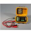
Features
? Dual input: pipe to soil and shunt
? Portable and rugged
? GPS synchronization with other survey
equipment
? Programmable waveform capture
? Every reading is time stamped
? ASCII comma delimited text file
? No special software required
? Comprehensive 1 year warranty
Ideal for
? Correction of CIPS data for stray currents
? Correction of CIPS data for tellurics
? Monitor pipe to soil potentials
Technical Specification
? Range - Channel 1: +/- 5 V DC or +/- 25 V DC
? Range - Channel 2: +/- 50 mV
? A/D Converter: 14 bit
? AC Rejection: 100 dB
? Memory Capacity: 1 Mb, expandable to 2Mb
? Input Impedance: 10 M ohm or 250 M ohm
? Case: Plastic with o-ring seal, IP67 rated
? Dimensions: 27cm x 25cm x 13cm (10.5” x 10” x 5”)
? Weight: 3.2 kg (7 lb)
? Battery: 7.2V 4.5 amp hour NiMH
? User interface: 240 x 64 graphic LCD with 40 key QWERTY membrane keypad
? Communications: RS-232
? GPS synchronized with external antenna
? Option to log GPS co-ordinates with every reading
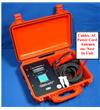
Included
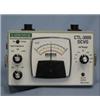
? Smart Logger II
? Test leads
? GPS magnet mount antenna
? AC charger; 120/240 V AC, 50/60 Hz
input
? RS-232 cable
? USB to RS-232 converter
? Owners manual
繪儀器/sb智能感應(yīng)器.jpg)
繪儀器/scm智能探針.jpg)
繪儀器/sp智能探針.jpg)
繪儀器/scm雜散電流測(cè)試儀.jpg)
發(fā)送器100.jpg)
繪儀器/si智能信號(hào)發(fā)生器.jpg)